
30/03/2024 -ETAPA 3 | STAGE 3 -> MEDIA (DEHESA BOYAL – FONTANAREJO)

ETAPA 3 -> MEDIA (DEHESA BOYAL – FONTANAREJO)
Mapa “Dehesa Boyal de Fontanarejo” (distinto)
Localidad Fontanarejo
Distancia Media
Extensión 3,0 km2
Escalas 1/10.000 – 1/7.500
Equidistancia 5 metros
Cartógrafos Mario Vidal Triquel
Altitud 550 – 600 m.
Trazador Jesús y Diego Rodríguez Corrochano. Últimos trazados: XV Trofeo Quijotes (Sigüenza)
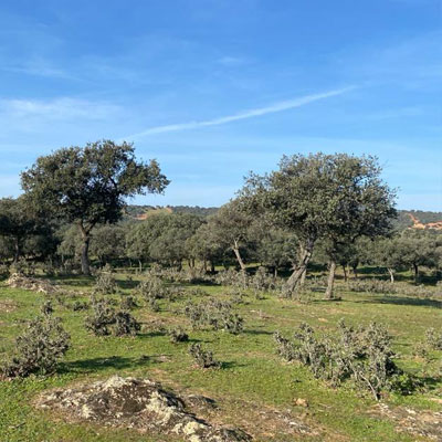
La Dehesa Boyal de Fontanarejo se asienta sobre un valle de muy suaves pendientes orientadas al
Sureste, con únicamente una ladera dominante al oeste y que supone en lo temático una parte diferenciada que comparte unidad con el resto del mapa en cuanto a que se trata de bosque de
encinas, pero sin embargo la más difícil accesibilidad le ha mantenido la condición de un espacio
menos transitable debido principalmente a la gran presencia de monte bajo y jara que reducen mucho
la velocidad
Sin embargo la mayor parte del mapa la forman suaves colinas con una gran visibilidad y
una superficie limpia y dura que aseguran altísimas velocidades de carrera
Por tanto, la topografía, que es uno de los pilares del mapa, se presenta bajo formas suaves que solo son acusadas allí donde aparecen y discurren torrentes estacionales en los que por otra parte aparecen las escasas formaciones rocosas presentes
También se encuentran detalles de vegetación de una importancia limitada, al igual que la definición de las masas arbóreas que suele ser imprecisa. Los tamaños de roca son generalmente pequeños estando el criterio de selección en torno a los 1 a 1,30 mts de altura, y en cuanto a cortados van de 0,90 a 1,20 mts.
La simbología, normalizada, no ofrece ninguna singularidad representativa, y los símbolos especiales se resumen en la identificación de algunos pero escasos elementos hechos por el hombre. En definitiva, un mapa agradable en vistosidad y que permite una navegación muy gratificante
Trazadores: Diego y Jesús Rodríguez Corrochano
Servicios en el Centro de Competición
- EN EL CENTRO DE COMPETICIÓN
o Secretaría
o Presalida
o Tv
o Tiendas
▪ Tienda de Orientación
▪ X-Tyme
▪ Orienteering Obsession
o Servicios de emergencia
o Restauración
▪ Patatas con costillas

STAGE 3 -> MEDIA (DEHESA BOYAL – FONTANAREJO)
The Dehesa Boyal de Fontanarejo sits on a valley with very gentle slopes facing the
Southeast, with only a dominant slope to the west and which thematically represents a part
differentiated that shares unity with the rest of the map in that it is a forest of
holm oaks, but nevertheless the most difficult accessibility has maintained the condition of a space
less passable due mainly to the large presence of scrubland and rockrose that greatly reduce
speed
However, most of the map is made up of gentle hills with great visibility and
a clean and hard surface that ensures very high running speeds
Therefore, the topography, which is one of the pillars of the map, is presented in soft forms that are only pronounced where seasonal torrents appear and flow in which, on the other hand, the few rock formations present appear.
Vegetation details of limited importance are also found, as is the definition of tree masses, which is usually imprecise. The rock sizes are generally small, with the selection criterion being around 1 to 1.30 meters high, and in terms of cuts they range from 0.90 to 1.20 meters.
The symbology, normalized, does not offer any representative singularity, and the special symbols are summarized in the identification of some but rare man-made elements. In short, a map that is pleasant in appearance and allows for very rewarding navigation.
Tracers: Diego and Jesús Rodríguez Corrochano